I told you I was done drawing distribution maps [1], but I found one more. At BYU's Bean Museum is a display of several animals from the North American taiga and tundra. It includes animals such as polar bears, arctic foxes, and caribou. Unlike most of the displays at the museum, these taxidermized animals had little signs that indicated their distribution. Most of them already had distribution maps created for them on Wikipedia. The only exception was the Rocky Mountain goat (Oreamnos americanus). So I made a map for it.
The map created by the Bean Museum actually wasn't very good, so I based my map on one I found on the internet that seemed pretty reliable.[2]
While wandering around the museum, looking for other distribution maps, I discovered a map showing the three different types of grassland in the Great Plains of North America. So I also recreated that map.
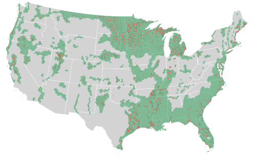
Finally, there was a wetlands display at the Bean Museum which had a map of the remaining wetlands areas in the United States, including areas which someone deemed critical for maintaining biodiversity (red dots).
As always, I inserted the maps into their relevant Wikipedia articles: Mountain goat, Great Plains, and Wetlands of the United States.
Notes:
[1] For the other distribution maps I've drawn, see here, here, here, here, and here.
[2] See http://www.ultimateungulate.com/Artiodactyla/Oreamnos americanus.html.
Image attributions:
Oreamnos americanus distribution is by Ninjatacoshell, available at http://commons.wikimedia.org/wiki/File:Oreamnos americanus distribution.svg.
Map of the Great Plains regions is by Ninjatacoshell, available at http://commons.wikimedia.org/wiki/File:US Great Plains Map.svg.
Map of US Wetlands is by Ninjatacoshell, available at http://commons.wikimedia.org/wiki/File:US Wetlands.svg.
 |
| Rocky Mountain Goat (Oreamnos americanus) |
The map created by the Bean Museum actually wasn't very good, so I based my map on one I found on the internet that seemed pretty reliable.[2]
 |
| Lime green = Short-grass prairie Green = Mid-grass prairie Dark green = Tall-grass prairie |
While wandering around the museum, looking for other distribution maps, I discovered a map showing the three different types of grassland in the Great Plains of North America. So I also recreated that map.
Finally, there was a wetlands display at the Bean Museum which had a map of the remaining wetlands areas in the United States, including areas which someone deemed critical for maintaining biodiversity (red dots).
As always, I inserted the maps into their relevant Wikipedia articles: Mountain goat, Great Plains, and Wetlands of the United States.
Notes:
[1] For the other distribution maps I've drawn, see here, here, here, here, and here.
[2] See http://www.ultimateungulate.com/Artiodactyla/Oreamnos americanus.html.
Image attributions:
Oreamnos americanus distribution is by Ninjatacoshell, available at http://commons.wikimedia.org/wiki/File:Oreamnos americanus distribution.svg.
Map of the Great Plains regions is by Ninjatacoshell, available at http://commons.wikimedia.org/wiki/File:US Great Plains Map.svg.
Map of US Wetlands is by Ninjatacoshell, available at http://commons.wikimedia.org/wiki/File:US Wetlands.svg.
No comments:
Post a Comment