When Leann and I went in to the BYU Student Health Center to get our influenza immunizations, I noticed a little pamphlet [1] that indicated (with world maps) what immunizations you would need based on where you were planning to travel. Most of these traveler's diseases already had equivalent distribution maps on Wikimedia Commons [2], but two didn't: influenza and meningococcal meningitis. So I made them.
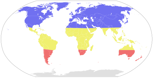
True influenza [3] is typically prevalent during the winter months. So in the northern hemisphere (blue areas) flu season is from November to April and in the southern hemisphere (red areas) it is from April to November. In the equatorial regions of the world (yellow areas) there is always a risk for influenza.[4] I inserted this image into the Wikipedia article on influenza.[5]
There is a high likelihood of contracting meningococcal meningitis in the equatorial regions of Africa, both for travelers and for natives. It is caused caused by the bacterium Neisseria meningitidis. If untreated there is a high probability of death or disfigurement. I inserted this image into the Wikipedia article on meningococcal disease.[6]
Notes:
[1] You can see it here.
[2] They were diphtheria, hepatitis A, hepatitis B, Japanese encephalitis, malaria, polio, rabies, tetanus, typhoid fever, and yellow fever. Some of them weren't great maps (e.g. malaria), but they weren't so terrible that I felt the need to replace them.
[3] To learn more about what is and isn't considered influenza, see my postThe Stomach Flu.
[4] New strains of the flu typically arise in southeast Asia
[5] See http://en.wikipedia.org/wiki/Influenza.
[6] See http://en.wikipedia.org/wiki/Meningococcal meningitis.
Image attributions:
Influenza Seasonal Risk Areas is by Ninjatacoshell, available at http://commons.wikimedia.org/wiki/File:Influenza Seasonal Risk Areas.svg.
Meningococcal Meningitis Range is by Ninjatacoshell, available at http://commons.wikimedia.org/wiki/File:Meningococcal Meningitis Range.svg.
True influenza [3] is typically prevalent during the winter months. So in the northern hemisphere (blue areas) flu season is from November to April and in the southern hemisphere (red areas) it is from April to November. In the equatorial regions of the world (yellow areas) there is always a risk for influenza.[4] I inserted this image into the Wikipedia article on influenza.[5]
There is a high likelihood of contracting meningococcal meningitis in the equatorial regions of Africa, both for travelers and for natives. It is caused caused by the bacterium Neisseria meningitidis. If untreated there is a high probability of death or disfigurement. I inserted this image into the Wikipedia article on meningococcal disease.[6]
Notes:
[1] You can see it here.
[2] They were diphtheria, hepatitis A, hepatitis B, Japanese encephalitis, malaria, polio, rabies, tetanus, typhoid fever, and yellow fever. Some of them weren't great maps (e.g. malaria), but they weren't so terrible that I felt the need to replace them.
[3] To learn more about what is and isn't considered influenza, see my post
[4] New strains of the flu typically arise in southeast Asia
[5] See http://en.wikipedia.org/wiki/Influenza.
[6] See http://en.wikipedia.org/wiki/Meningococcal meningitis.
Image attributions:
Influenza Seasonal Risk Areas is by Ninjatacoshell, available at http://commons.wikimedia.org/wiki/File:Influenza Seasonal Risk Areas.svg.
Meningococcal Meningitis Range is by Ninjatacoshell, available at http://commons.wikimedia.org/wiki/File:Meningococcal Meningitis Range.svg.


No comments:
Post a Comment